


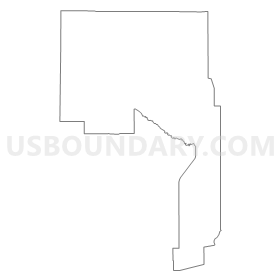
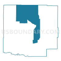
Crowley 3, Crowley County, Colorado
About
Outline
Summary
| Unique Area Identifier | 547120 |
| Name | Crowley 3 |
| County | Crowley County |
| State | Colorado |
| Area (square miles) | 149.74 |
| Land Area (square miles) | 147.84 |
| Water Area (square miles) | 1.89 |
| % of Land Area | 98.74 |
| % of Water Area | 1.26 |
| Latitude of the Internal Point | 38.42821220 |
| Longtitude of the Internal Point | -103.81388250 |
Maps


Graphs
Select a template below for downloading or customizing gragh for Crowley 3, Crowley County, Colorado


Neighbors
Neighoring Voting District (by Name) Neighboring Voting District on the Map
- Crowley 1, Crowley County, CO
- Crowley 2, Crowley County, CO
- Crowley 4, Crowley County, CO
- Crowley 5, Crowley County, CO
- Crowley 6, Crowley County, CO
- Lincoln 11, Lincoln County, CO
- Lincoln 12, Lincoln County, CO
Top 10 Neighboring County Subdivision (by Population) Neighboring County Subdivision on the Map
- Ordway CCD, Crowley County, CO (5,398)
- Karval CCD, Lincoln County, CO (651)
- Sugar City CCD, Crowley County, CO (425)